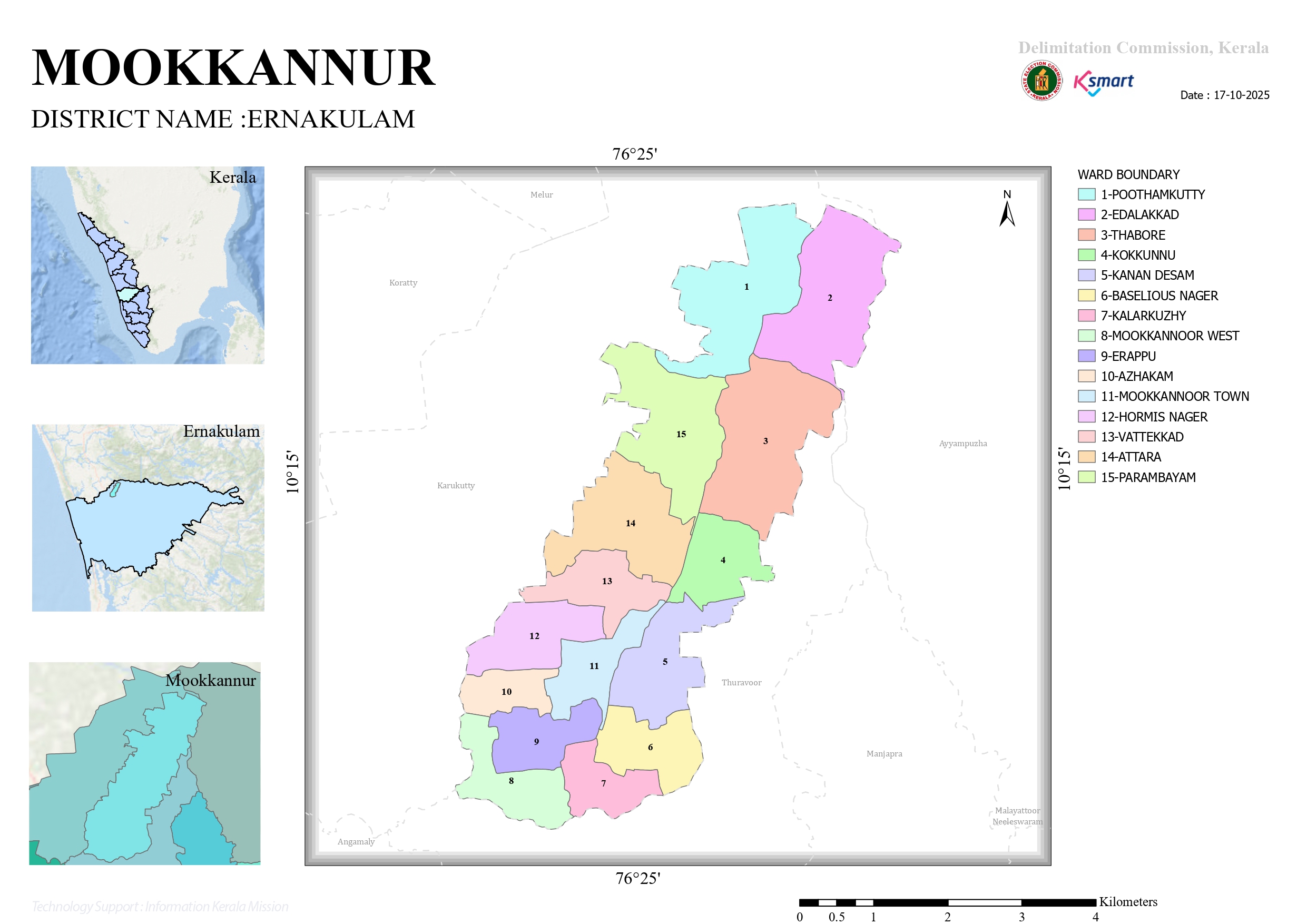

Map 2025
Below is a polished English version suitable for a Panchayat website, Development Report, GIS Report, or Citizen Charter.
Mookkannoor Grama Panchayat – Ward Delimitation Report 2025
Introduction
This report summarizes the final order issued by the Delimitation Commission, Kerala, regarding the reorganization of wards in Mookkannoor Grama Panchayat. As per the 2025 ward delimitation, the Panchayat has been divided into 15 electoral wards, with the population and boundaries of each ward clearly defined.
Ward Delimitation – Overview
Under Section 10 of the Kerala Panchayat Raj Act, 1994, the number of members to be elected directly to Mookkannoor Grama Panchayat has been fixed at 15. Accordingly, the Panchayat has been divided into 15 electoral wards, and the final delimitation order has been issued.
Ward-wise Population Details
| Ward No. | Ward Name | Population |
|---|---|---|
| 01 | Poothamkutty | 1,229 |
| 02 | Edalakkad | 1,247 |
| 03 | Thabor | 1,396 |
| 04 | Kokkunnu | 1,361 |
| 05 | Canaan Desam | 1,311 |
| 06 | Baselios Nagar | 1,297 |
| 07 | Kalarkuzhi | 1,215 |
| 08 | Mookkannoor West | 1,373 |
| 09 | Erappu | 1,300 |
| 10 | Azhakam | 1,346 |
| 11 | Mookkannoor Town | 1,235 |
| 12 | Hormis Nagar | 1,273 |
| 13 | Vattekkad | 1,297 |
| 14 | Attara | 1,416 |
| 15 | Parambayam | 1,332 |
Key Observations
- Most populous ward: Attara (1,416 residents)
- Least populous ward: Kalarkuzhi (1,215 residents)
- Average ward population: Approximately 1,304 residents
- Ward boundaries have been delineated primarily using PWD roads, canal bunds, streams, and Grama Panchayat boundaries.
Website Summary
Mookkannoor Grama Panchayat is presently divided into 15 wards. The ward boundaries and population distribution were revised in accordance with the final order of the Delimitation Commission, Kerala, issued in 2025. Natural and administrative features such as roads, canals, streams, and Panchayat boundaries have been used to ensure balanced representation across all wards.
Mookkannoor Grama Panchayat Ward Map – Analytical Report
1. General Information
Mookkannoor Grama Panchayat is located in Ernakulam District, Kerala. The Ward Map published by the Delimitation Commission, Kerala, in 2025 clearly depicts the boundaries of the Panchayat’s 15 electoral wards.
2. List of Wards
- Poothamkutty
- Edalakkad
- Thabor
- Kokkunnu
- Canaan Desam
- Baselios Nagar
- Kalarkuzhi
- Mookkannoor West
- Erappu
- Azhakam
- Mookkannoor Town
- Hormis Nagar
- Vattekkad
- Attara
- Parambayam
3. Geographical Location
The Panchayat shares its boundaries with the following neighboring local bodies:
- Karukutty
- Manjapra
- Ayyampuzha
- Thuravoor
These neighboring Panchayats strengthen Mookkannoor’s regional connectivity and development prospects.
4. Notable Features of the Ward Layout
- Mookkannoor Town (Ward 11) is situated at the center of the Panchayat and functions as the primary administrative and commercial hub.
- Baselios Nagar (Ward 6) and Kalarkuzhi (Ward 7) are located in the south-eastern region.
- Poothamkutty (Ward 1), Edalakkad (Ward 2), and Thabor (Ward 3) are situated in the north-eastern part of the Panchayat.
- Azhakam (Ward 10), Erappu (Ward 9), Vattekkad (Ward 13), Attara (Ward 14), and Parambayam (Ward 15) occupy the western and south-western areas.
5. Development Significance
The ward reorganization:
- Ensures balanced population distribution.
- Enhances the efficiency of local governance.
- Facilitates ward-based planning and implementation of development projects.
- Improves the functioning of Gram Sabhas, Ward Sabhas, and welfare programmes.
- Strengthens democratic representation at the grassroots level.
6. Conclusion
The 2025 Ward Map of Mookkannoor Grama Panchayat serves as a fundamental framework for governance, planning, and development. The division into 15 wards strengthens public representation and promotes equitable distribution of development resources. It will also support more effective implementation of infrastructure projects, welfare schemes, and future development initiatives on a ward-wise basis, contributing to the sustainable growth of the Panchayat.